Showing posts with label Maps. Show all posts

Wednesday, November 19, 2008

Map update: 19 November

I write this from Toronto, where my bus safely arrived this afternoon. Above is the completed map, roughly broken into the two halves of the trip (black = first half; blue = second half).

Below is the day-by-day map. It's a bit hard to follow in some places, and I spent multiple days in a few places, of course, but it at least illustrates how long (and short) some of the trips were. Check out Chicago to Denver, Albuquerque to Austin, and Atlanta to Toronto. Man oh man. Never do that.

Saturday, November 15, 2008

Map update: 15 November

Ah, it's good to be home (away from home) here in sunny, if chilly, New Orleans. The bus was about 20 minutes late, but no matter. I ate pizza with NOLA Cole (a friend of NOLA Sean, and now a friend of mine) and all is swell.

You know, that map is looking pretty full by now...

Wednesday, November 12, 2008

Map update: 12 November


So I just got off the bus in Austin. It was an 18-hour trip across New Mexico and much of the Great State of Texas. By the way, it's just as big as it looks on the map.

Don't ever do what I just did. Somehow, the 23-hour trip from New Orleans to Chicago and the 24-hour trip from there to Denver both seemed easier to endure than today's beast of a ride.

Unfortunately, there were no real characters of note on any of today's three buses.

One woman going to Florida who didn't trust anything I said about our next destinations (that I was right every time isn't much of a boost. I just learned how to read directions as a child.). One drunk Texan who kept accosting people. A teenager coming back from Marine Corps training in San Diego. You know, same 'ol.

So that's that. Oh, and the blue on the map is sort of what I'm considering the second half of the trip, if only because I'm moving back to time-zone sanity (i.e. Eastern Standard Time).

Thursday, November 6, 2008

Map update: 06 November

As you can see, Greyhound doesn't always allow you to go in straight lines. That last 23-hour leg (24, actually, since we dropped a time zone) was something else. Turns out Kansas looks exactly how you think it would.

Tumbleweed.
Rolling.
Slowly.

Cars kicking up dust on dirt roads reaching to the horizon.
And the flattest horizon you can imagine.

Night and day are interchangeable 0n the Great Plains.

Monday, November 3, 2008

Map update: 03 November

Wow. When I woke up this morning, we were lumbering along I-57, making the final charge to Chicago. In the night, I think the bus wound through Arkansas and Missouri. But I don't think that counts on my Official State Count, does it?

Anyways, I'm sitting in a cafe just east of Canal Street and just west of what I assume is the Chicago River. The Sears Tower is nearby, and it's quite tall. I feel like I should resent its height just on principle, having been born near the world's (former) tallest free-standing structure tower building.

I believe I have a place to stay. This time with a friend of a friend of a friend. Because I trust everyone in the world, this should be easy.

Tomorrow: cameo appearance on Thirty Days made by friends from Ottawa.
Also tomorrow: cameo appearance by potential president-elect

Thursday, October 30, 2008

Map update: 30 October


Made it to New Orleans!

This city might have more character than anywhere else in the world.

I'm comfortable saying that even though I have only ever been to three countries and never to continental Europe. Call me wrong if you want. I dare you to provide a better example.

(Map pending; not the greatest connection here at the CC House at Magazine/Jefferson)

Monday, October 27, 2008

Map update: 27 October

Distance covered so far. I think it has been 12 buses so far. There is still so far to go to get to California. Onward!

Friday, October 24, 2008

Eighteen hours through the Appalachians

Not everything always goes according to plan. Case in point: Columbus, Ohio was not part of the plan for Thirty Days. But the way Greyhound travels the land isn't always the most convenient.

As the map illustrates, West Virginia and Kentucky border each other. But in order to get from Charleston to Lexington, you have to transfer (twice!) in Ohio: Columbus and Cincinnati.

Even though the trip cuts through part of Kentucky no more than two hours from Lexington.

All of this made today a little longer, and it's the reason I decided to spend the night in Columbus.

Thursday, October 23, 2008

Map update: 23 October


This is my progress so far. Next stop is Charleston, West Virginia. The bus leaves tonight at 1 a.m. Then it's on to Kentucky, Tennessee, Alabama, Mississippi (briefly) and Louisiana.

UPDATE: Part of the itinerary for the next few days looks like this:

D.C. to Charleston, WV
02h15 to 14h45
Overnight

Charleston to Lexington, KY
01h30 to 13h25
Overnight

Lexington to Nashville, TN
22h30 to 05h20
Overnight

Then a hostel/motel!

Nashville to Birmingham, AL
11h20 to 15h50
And then a motel, for sure!

Three nights on a bus in a row. I don't know if that makes sense or not. I think not. I guess we'll see.

Monday, October 20, 2008

Bangor to Boston and beyond

Tomorrow morning, after filing a story for MediaScout, I'm jumping on a bus headed to Boston. After that, the tentative itinerary sort of looks like this:
  • Washington, D.C.
  • Lexington, KY
  • Nashville, TN
  • Birmingham, AB
  • New Orleans, LA
  • Memphis, TN or Austin, TX
Friends and acquaintances are on standby.

See ya in a month, Canada

Today was a long day. Twelve hours, two buses, two provinces, and one state later, I'm sitting in a hotel room a couple of miles northwest of Bangor, Maine. A few notes from the road:
  • 10 minutes after crossing the border into Calais, Maine, and I saw a bald eagle. How freaking predictable is that?
  • We passed by a 500m peak called Lead Mountain. I'm from such a boring province that this seemed exciting. You'd think Ontario, in all its enormity, would find a place for a mountain. Instead, hills. Softly rolling hills.
  • In rural Maine, McCain-Palin signs vastly outnumber Obama-Biden. But in Bangor, the largest town east of Augusta (the state capital, also not very large), Obama signs on private property outnumber McCain's by about 6:1. There are no Obama signs on public property, where the McCain people have staked their territory.
    Rural Maine: leaning red
    Bangor: blue as Paul Bunyan's famous ox
Oh, I should explain that otherwise non-sequiturial reference. I got lost on the way to my hotel (Econolodge by the airport). But while wandering around, I came across Paul Bunyan in statue form. Bangor is one of several American towns to claim themselves as Bunyan's place of birth.

Here he is:


How exactly did I get lost? Behold.


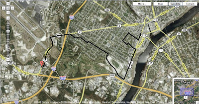
Notice the airport. I can hear planes from my hotel room, which faces the landing strip, and as I walked underneath it along Odlin Road a Navy cargo jet flew over. It was just like Wayne's World. Whoooaaaa!

Man, another one just landed. I think the Navy is having a party tonight. Where's my invite?

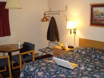
The hotel room, just in case you haven't seen enough pictures:


Friday, October 17, 2008

Rough sketch of the first leg

This is, I think, how I plan to spend the first few days of the trip.

First stop: Halifax (not pictured). On Oct. 20, I leave Halifax on a bus bound for Bangor, Maine. After that, it's off to Washington D.C. after stops in Boston and New York. Everything after that on this map might not actually happen. Come to think of it, that sort of uncertainty might come to define this adventure.

I don't know if I'm entirely comfortable with that.